|
|
|
|
Severe weather discussions are geographical discussions that highlight certain severe weather events. For more information on how these products are produced, e-mail us at phlweather@lycos.com.
VALID SWDs
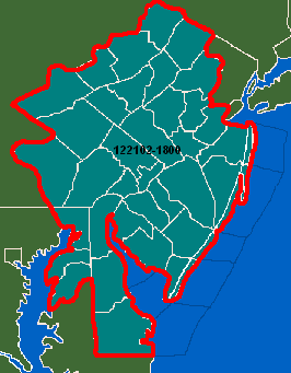
122102-1800 - winter storm potential.
SWD Color Codes
To get discussions e-mailed to you, join the phlweather eGroup or, click here (provide us with your county/state for discussions or indicate 'all' to recieve all alerts.)
122102-1800
Winter storm potential
Valid for: Berks, Bucks, Carbon, Chester, Delaware, Lancaster, Lehigh, Monroe, Montgomery, Northampton, Philadelphia, Pike and Schuylkill PA. Atlantic, Burlington, Camden, Cape May, Cumberland, Gloucester, Hunterdon, Mercer, Middlesex, Monmouth, Morris, Ocean, Salem, Somerset, Sussex and Warren NJ. Kent, New Castle and Sussex DE. Cecil, Kent and Queen Anne's MD. Coastal sections from Sandy Hook, NJ to Fenwick Island, DE.
Including the cities of: Allentown, Bethlehem, Chester, Doylestown, Lancaster, Milford, Mount Pocono, Norristown, Philadelphia, Pottsville, Stroudsburg, Reading, Philadelphia and West Chester PA. Andover, Atlantic City, Camden, Cape May, Cherry Hill, Flemington, Millville, Morristown, Phillipsburg, Sussex, Trenton, Vineland, Willingboro and Wrightstown NJ. Dover, Newark and Wilmington DE. Chestertown and Elkton MD.
Issued: 6:00pm - December 21, 2002
Expires: 6:00pm - December 23, 2002
...WINTER STORM WILL LIKELY AFFECT THE REGION ON CHRISTMAS DAY...
A POTENT STORM SYSTEM NOW MOVING ASHORE IN CALIFORNIA WILL MOVE ACROSS THE SOUTHWEST STATES AND INTO THE ARKLATEX REGION BY EARLY NEXT WEEK. BY TUESDAY...THE CENTER OF THE STORM SHOULD BE IN THE TENNESSEE RIVER VALLEY. SECONDARY LOW PRESSURE OFF THE NORTH CAROLINA COAST WILL TAKEOVER BY EARLY CHRISTMAS DAY BEFORE MOVING UP THE COAST OFFSHORE. IF ENOUGH COLD AIR IS IN PLACE COME CHRISTMAS DAY...SNOW WILL BE POSSIBLE FROM THIS POTENTIALLY SIGNIFICANT WINTER STORM.
AS ALWAYS...THE TYPE...AMOUNT AND DURATION OF PRECIPITATION WILL DEPEND ON THE EXACT TRACK AND STRENGTH OF THE LOW PRESSURE SYSTEMS. AT THIS TIME...IT APPEARS SNOW WILL BE LIKELY ON CHRISTMAS DAY NORTH AND WEST OF PHILADELPHIA AND THE I-95 CORRIDOR. IN THE PHILADELPHIA METROPOLITAN AREA AND POINTS SOUTH INCLUDING THE DELMARVA AND SOUTHERN NEW JERSEY...EITHER RAIN OR SNOW COULD FALL DEPENDING ON THE TRACK OF THE STORM. MAINLY RAIN CAN BE ANTICIPATED ALONG MUCH OF THE COASTLINE. SIGNIFICANT SNOW ACCUMULATIONS WILL BE POSSIBLE IN ANY LOCATION THAT SEES MAINLY SNOW.
SINCE THE STORM IS EXPECTED TO ARRIVE ON CHRISTMAS DAY...THE OVERALL TRAVEL IMPACT SHOULD BE MINIMAL...HOWEVER...BEING STILL FOUR DAYS OUT IN THE FORECAST...TIMING MAY BE ALTERED UPON REVIEW OF FUTURE COMPUTER MODEL DATA. STAY TUNED TO YOUR LOCAL MEDIA OUTLETS FOR FURTHER DETAILS AND UPDATES.
THIS SEVERE WEATHER DISCUSSION EXPIRES ON 6PM MONDAY EVENING.
Technical
N/A.